Support the Crespogram

THE REPORT BELOW MIGHT BE THE MOST IMPORTANT DOCUMENT THAT YOU'VE NOT HEARD ABOUT OR SEEN REGARDING THE IMPACT OF A HURRICANE TO OUR COMMUNITY. THE FACT THAT YOU'RE BEING TOLD ABOUT THIS FROM ME, AND NOT YOUR ELECTED OR APPOINTED OFFICIALS OUGHT TO ALARM YOU
MIAMI SHORES #3 - JUNE 12, 2018
At the Village Council meeting of October 17, 2017, the Council approved spending $60,000 of our tax dollars for an environmental vulnerability study of the impact of sea level rise in our community.


108 to 122.pdf by al_crespo on Scribd
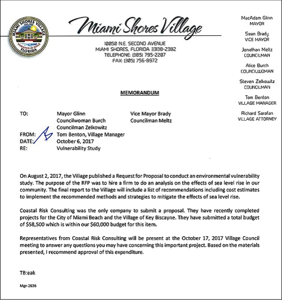
The above report was the result of that effort, and from its cover, it appears to have been delivered to the Village in February of 2018.
A review of the minutes of all the Village Council meetings from February 1st to the last meeting on June 5th, indicates that the results of this report was never presented or discussed in public by either Village Manager Tom Benton, the Mayor, or any of the members of the council.
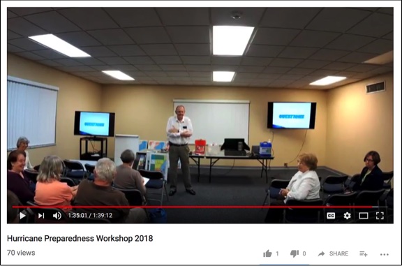
The only time that any portion of this report was made public was during the Hurricane Preparedness Presentation that Tom Benton made at the Recreation Center on May 23rd, where he showed three slides from the report, without identifying where these slides had come from, or that they were part of a report that the council had commissioned and that the Village residents had paid for.
Here is the portion of his presentation where the slides were presented.
As of today, You Tube shows that a total of 70 viewers logged on to look at the video.

On Monday morning, I wrote and asked Benton to provide me with an estimate of how many residents has attended his presentation.
As of now, he has not responded, but that's okay, being petulant and unresponsive only serves to provide me more evidence of personal discrimination.
A look at the screen grab above though indicates that the meeting was not attended by a whole of of residents, so in an effort to be charitable, lets say that 50 residents did attend, and another 70, as indicated by the counter on YOU TUBE, watched the video.
That's a total of roughly 120 residents out of an estimated population of 10,000 folks who live in the Village, who've have had expose to any portion of this $60,000 study that's been in the possession of the Village Manager since February.
ALICE BURCH WANTED A SPECIAL ASSESSMENT
I first became aware of this report at the end of last week's Council meeting when Alice Burch introduced a discussion item to raise the Stormwater Fees to incorporate them in this coming year's budget.
It's not unusual for a politician to introduce a tax increase - and a special assessment is a tax increase by another name - at the end of a meeting when few people are paying attention, so that was the first thing that caught my attention.
The second thing that rang an alarm bell was when I heard Mayor MacAdam Glinn comment during the discussion about this item acknowledge his support for this item by saying: (See at 4:00 in video below.)
"If you saw the map of our recently completed assessment,
ugh, flood assessment in the comp plan, it's unbelievable."
That got my attention. What recently completed flood assessment? What map?
When I went home, I immediately logged on the the Village website pulled up the agenda of the meeting with the backup documents, and towards the end of the backup material, on page 128, I discovered a copy of the above Flood Vulnerability Assessment, included as Attachment "A."
After looking the document over, I returned to the Village website to see whether this report had been posted anywhere on the website for the residents to access.
It had not.
The next morning, after looking over the report once again, I sent the following email to the Mayor, the Council members, the Village Manager and the Village Clerk.
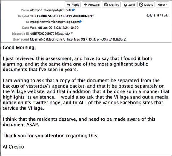
That was last Wednesday morning. Since then the only response I got from the Mayor and Council was from Councilman Sean Brady, who on Monday afternoon wrote me:

I appreciate Sean Brady's response, but the fact of the matter is that it is, and was the responsibility of Tom Benton, the Village Manager to see that this report was posted prominently on the Village's website so that the residents - whose $60,000 paid for this report - could read and make their own assessments about the information in this report. Inserting this report as an attachment in a 148 page backup of agenda items is not what one should consider an act of transparency and openness.
The failure, whether it was intentional, or just one more example of the general level of laissez faire incompetence that some people find a charming attribute in the way that Tom Benton manages this Village, underscores the continued willingness of many residents in the Village to ignore the potential calamity that will follow any CAT 3 or above hurricane, especially those who live closest to Biscayne Bay.
QUIBBLING OVER WHETHER YOU LIVE IN THE RED, YELLOW OR GRREN AREAS IS FOOLISH
Aa a photojournalist I have taken thousands of photographs during hurricanes and after hurricanes. many of them capturing the drama, destruction and human misery that storms leave behind.
Of all of those thousands of photographs however, the one that has always remained first and foremost in my mind as evidence of just how unpredictable a hurricane can be, and how incapable we humans are at controlling water, is this photograph, I took at the overpass of State Road 43 and I-10, north of Bay St Louis, Mississippi, after Hurricane Katerina.
You see that brown line that I've highlighted with the arrow?
That's the height of the water that reached that overpass. It's water that didn't come directly from the Gulf of Mexico, but rather it came from the storm surge that got inside St Louis Bay, and flooded land for miles along the coast, including this overpass which was over 6 miles from the Gulf of Mexico, and about a mile and a half from the Bay.

Given the right conditions, a Category 5 storm could result in a smilar line of debris the entire length of I-95.
I expect that in the next day or two that this report will be posted on the Village's website. It should have been posted on the site months ago, and instead of it being an attachment to another document, this report should have received the proper attention it deserved from both the Manager and the Mayor, who, if he really believed that the information in the report was:
"If you saw the map of our recently completed assessment,
ugh, flood assessment in the comp plan, it's unbelievable."
He owed it to the residents to make us all aware of just how "unbelievable" the information in the report really was!
I am a firm believe that taxpayers should get value for their money, and one of the ways that you can measure whether that is happening is how transparent your public officials are in providing you with reports like the one above that can impact on your quality of life, especially when you are the ones paying for this information.
In this case, the attitude of your elected officials seems to have been that you didn't deserve being provided with a copy of this document.

VIDEO OF MONDAY NIGHT'S MEETING BETWEEN WEST GROVE OWNERS OF SHOTGUN HOUSES AND CITY'S PLANNING & HISTORIC PRESERVATION STAFF
